geospatial
9 TopicsAI-Enabled Map Production Using Microsoft's MARS Model
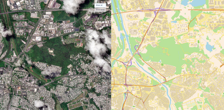
Maps have long served as the foundation for how organizations understand, navigate, and make decisions about the world. Yet generating and maintaining maps remains a highly manual, time-consuming, and costly process with susceptibility to human error. Traditional mapping workflows rely on skilled cartographers to manually analyze satellite imagery, identify geographic features with a human eye, and digitize them into map layers. The challenge of keeping maps up to date is well said by Michael Harres, SVP of Engineering Maps at TomTom. “Traditional maps, including early digital versions, were static snapshots, reliant on manual updates, outdated and unable to reflect real-time changes.” - Michael Harres, SVP of Engineering Maps at TomTom (Source: From Paper To AI: The Evolution Of Maps And What’s Next) While recent advances in generative AI have demonstrated impressive visual reasoning capabilities, most general-purpose models are not designed to generate the structured vector outputs (e.g. points, lines, and polygons) required by GIS workflows. They often produce rasterized sketches, illustrations, or incomplete representations that cannot be directly incorporated into enterprise mapping systems. ple Output from a General-Purpose AI Model Prompted to Generate a Map Today, we are excited to release the Map Autoregressive (MARS) model on Microsoft Foundry! MARS is a Geospatial AI model that automatically converts satellite imagery directly into structured, GIS-ready vector map data. Unlike traditional mapping approaches that rely on complex multi-stage pipelines, heuristic processes, and extensive post-processing, MARS’s key differentiator is its unified end-to-end architecture that automatically extracts geographic features and generates vector representations suitable for mapping and geospatial analysis. Unlike segmentation masks, vector outputs can be directly loaded into GIS systems, edited by analysts, and incorporated into downstream mapping, analytics, and operational workflows. Trained on large-scale geospatial datasets, MARS currently supports feature extraction for buildings, roads, railways, and waterbodies with a scalable ontology designed to expand over time. Microsoft recently published a research paper on MARS (http://aka.ms/marspaper), accepted by the International Conference on Learning Representations (ICLR) Conference, that provides a deep technical overview of the model’s architecture, training methodology, and performance. The MARS model from the paper uses the same architecture, adapted through a separate training process, and attains state-of-the-art performance on public benchmarks. Metrics for the Foundry model are available on its model card, which also demonstrates its ability to generate GIS-ready vector representations directly from satellite imagery. Figure 2: Microsoft MARS Model – This image shows a feature extraction output of MARS overlaid on input aerial imagery of London. The extracted features are rendered directly on top of the source image to illustrate how the model converts raw imagery into structured geospatial data. Buildings, roads, railways, and waterbodies represented as vector geometries, enabling organizations to generate and update maps at scale without labor-intensive manual digitization. Legend: Buildings → Orange polygons Roads → Yellow lines Railways → Red lines Waterbodies → Blue shaded polygons The Value of Automated Feature Extraction using MARS The volume of Earth observation data, and the pace at which infrastructure is changing around the world, is growing faster than organizations can manually track. As a result, there is an increasing need for automated solutions that can transform imagery into up-to-date maps at scale. With the MARS model, organizations can: Accelerate map production workflows with vectorized GIS outputs of map features Reduce manual human-labeling efforts Scale mapping operations across larger regions or under-represented areas Increase map update frequency Improve situational awareness Make faster, data-driven decisions MARS can be run with satellite images from geospatial data platforms, like Microsoft Planetary Computer Pro, providing an end-to-end workflow for automated map production. Users can ingest and manage aerial imagery within Microsoft Planetary Computer Pro, where data is stored and indexed using the STAC (Spatial Temporal Asset Catalog) standard for efficient discovery and search. MARS can perform feature extraction using input data from a user’s Microsoft Planetary Computer Pro GeoCatalog, with the resulting outputs stored back into Microsoft Planetary Computer Pro for downstream analysis. By seamlessly integrating data management and GeoAI inference into a single workflow, MARS and Microsoft Planetary Computer Pro help organizations transform raw satellite imagery into usable maps. Potential Applications Mapping underpins mission-critical workflows across government and commercial industries. When maps become incomplete, outdated, or inaccurate, the decisions and insights built on them can carry significant operational risk. As organizations increasingly invest in digital twins, geospatial analytics, and map-based decision making, there is growing demand for scalable AI-enabled solutions that can transform imagery into GIS map data. Here are several potential applications of MARS. Government and intelligence communities around the globe invest significant resources producing and maintaining maps because roads, buildings, and critical infrastructure are essential to mission planning, reconnaissance, operational logistics, disaster response, and situational awareness. Currently, producing maps often requires analysts to manually review imagery, digitize features, and reconcile information from multiple sources, which is a time-consuming and error prone process that struggles to keep pace with a rapidly changing world. Using MARS, analysts can automatically generate GIS-ready vector outputs from satellite imagery, dramatically reducing the effort required to update maps at a fraction of the cost compared to traditional workflows. Infrastructure operators, utilities, and transportation agencies currently rely on aerial surveys, field inspections, engineering reports, and manually maintained GIS datasets to track changes in the built environment. These approaches can be manual, costly, time-consuming, and difficult to perform frequently across large regions. To address these challenges, MARS provides automated feature extraction from satellite imagery, replacing labor-intensive mapping workflows with scalable, AI-driven map production. This enables organizations to maintain more current geospatial datasets for infrastructure planning, grid modernization, renewable energy expansion, and transportation network management. Telecommunication providers currently combine GIS analysis, third-party mapping datasets, demographic studies, and site surveys to determine where to expand network coverage networks across underserved and rapidly growing areas. However, these datasets can quickly become stale in rapidly growing areas, leading to missed opportunities, inaccurate coverage planning, and costly field validation efforts. MARS enables providers to continuously derive fresh GIS-ready vector data from satellite imagery, helping teams identify service coverage gaps, prioritize infrastructure investments, and accelerate broadband expansion into underserved regions. Mining and natural resource companies frequently use field surveys, drone operations, engineering assessments, and GIS teams to monitor roads, operational infrastructure, and site expansion across vast and remote regions to support mineral exploration, mine planning, and infrastructure management. Updating these datasets often requires significant manual effort and can lag behind changing on-the-ground conditions. MARS can continuously extract and update road networks, waterway features, and operational infrastructure across vast and often remote regions, enabling faster planning cycles and more informed operational decisions. Insurance providers currently rely on stale property records, government datasets, aerial surveys, and manual assessments to maintain property inventories and evaluate risk exposure. MARS can help maintain property inventories and accelerate risk assessment by automatically extracting building footprints and detecting changes from recent satellite imagery. Following natural disasters such as floods, hurricanes, or wildfires, insurers can generate up-to-date maps of buildings, roads, and communities to assess exposure, prioritize inspections, expedite claims triage, and improve portfolio management using current geospatial data rather than infrequent surveys and manually maintained datasets. As organizations increasingly invest in digital twins and smart city initiatives, MARS provides a scalable way to keep virtual representations synchronized with the physical world. Automatically extracting buildings, transportation networks, and other critical assets from new imagery helps ensure digital twins remain current and ready to support planning, simulation, and operational decision-making. Getting Started MARS is available today on Microsoft Foundry. To get started, 1. Deploy the MARS model from the Microsoft Foundry Model Catalog. a. You may need to request additional GPU compute quota in Microsoft Foundry (https://learn.microsoft.com/en-us/azure/foundry/how-to/quota). The MARS model requires the Standard_NC24ads_A100_v4 VM. 2. Set up your Azure Microsoft Planetary Computer Pro instance. 3. Within Microsoft Planetary Computer Pro GeoCatalog, ingest input satellite imagery data as a Spatial Temporal Asset Catalog (STAC) collection of Cloud Optimized GeoTIFFs (COGs). Commercial data is available from various providers and partners like SkyWatch. a. Input Imagery Recommended Specifications: i. Orthorectified satellite or airborne imagery with a ground sample distance (GSD) between 25cm – 75cm (the optimal GSD is 60cm) ii. Ingested into Planetary Computer Pro as an RGB COG and STAC metadata that specifies gsd, projection (e.g. proj:epsg), band information (e.g eo:bands), and accurate bounding box (bbox) and geometry fields b. Recommend Model Settings i. Optimal tiling: 512 x 512 pixels 4. Use the GeoAI SDK to run MARS against imagery from your Microsoft Planetary Computer Pro collection. 5. Generate production-ready vector layers for analysis, mapping, and downstream applications. References AI Model Catalog | Microsoft Foundry Models GeoAI SDK — GeoAI with Microsoft Planetary Computer Pro MARS - A Foundational Map Auto-Regressor | OpenReview Microsoft Planetary Computer Pro | Microsoft Azure Microsoft Planetary Computer Pro | Microsoft Learn4.1KViews3likes0CommentsUnified AI Weather Forecasting Pipeline thru Aurora, Foundry, and Microsoft Planetary Computer Pro
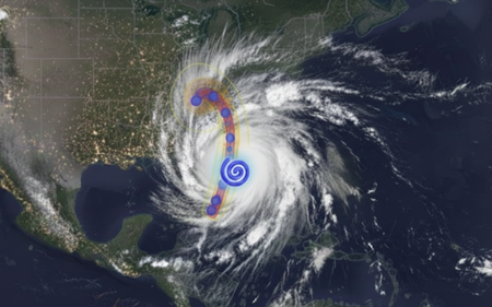
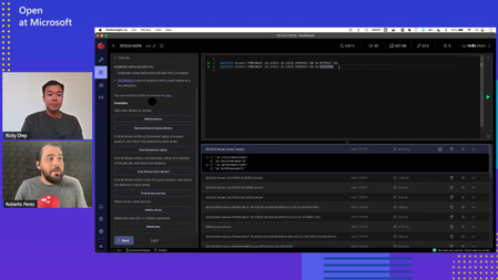
Weather shapes some of the most critical decisions we make, from protecting our critical infrastructure and global supply chains, to keeping communities safe during extreme events. As climate variability becomes more volatile, an organization’s ability to predict, assess, and plan their response to extreme weather is a defining capability for modern infrastructure owners & operators. This is especially true for the energy and utility sector — even small delays in preparations and response can cascade into massive operational risk and financial impacts, including widespread outages and millions in recovery costs. Operators of critical power infrastructure are increasingly turning to AI-powered solutions to reduce their operational and service delivery risk. “As the physical risks to our grid systems grow, so too does our technological capacity to anticipate them. Artificial intelligence has quietly reached a maturity point in utility operations-not just as a tool for optimization, about as a strategic foresight engine. The opportunity is clear: with the right data, infrastructure, and operational alignment, AI outage prediction utility grid strategies can now forecast vulnerabilities with precision and help utilities transition from reactive to preventive risk models.” – Article by Think Power Solutions Providing direct control of their data and AI analytics allows providers to make better, more actionable insights for their operations. Today, we’ll demonstrate and explore how organizations can use the state-of-the-art Aurora weather model in Microsoft Foundry with weather data provided by Microsoft Planetary Computer (MPC), an Azure based geospatial data management platform, to develop a utility industry-specific impact prediction capability. Taking Control of your Weather Prediction Microsoft Research first announced Aurora in June 2024, a cutting-edge AI foundation model enabling locally executed, on-demand, global weather forecasting, and storm-trajectory prediction generated from publicly available weather data. Two months later, Aurora became available on Microsoft Foundry elevating on-demand weather forecasting from a self-hosted experience to managed deployments, readying Aurora for broader enterprise and public adoption. Aurora’s scientific foundations and forecasting performance were peer‑reviewed and published in Nature, providing independent validation across global benchmarks. Its evolution continues with a strong commitment to openness and interoperability: In November 2025, Microsoft announced plans to open-source Aurora to accelerate innovation across the global research and developer community. Building upon the innovation and continued development of Aurora, today we are showcasing how organizations can operationalize this state-of-the-art capability with Microsoft Planetary Computer and Microsoft Planetary Computer Pro. By bringing together the vast public geospatial data stores in Planetary Computer, with the private data managed by Planetary Computer Pro, organizations can unify their weather prediction and geospatial data in a single platform, simplifying data processing pipelines and data management. This advancement allows enterprise customers to take control of their own weather forecasting on their own timeline. A Unified Weather Prediction Data Pipeline In addition, a key pain-point for energy and utility companies is the inability to reliably ingest, store, and operationalize high-volume weather data. Model inputs and outputs often sit scattered across fragmented pipelines and platforms, making decisions difficult to trace, reproduce, and reference over time. For example, referenced in articles, many utility companies have to pull public data from various silos, maintain GIS layers in another, and run operational planning in a separate environment—forcing teams to manually stitch together forecasts, assets, and risk assessments, introducing delays exactly when rapid decisions matter most. With the MPC Pro + Microsoft Foundry pipeline, utility companies transition from fragmented, manual workflows to a single operating platform – where the value lies in a seamless end-to-end data-to-model pipeline. Users can leverage Aurora on Microsoft Foundry alongside Microsoft Planetary Computer Pro’s geospatial data platform to unlock the following unified workflow: Source near real time weather data from Planetary Computer Run Aurora in Microsoft Foundry Fuse weather prediction results with geospatial data in Planetary Computer Pro for rapid assessment and post processing A Ready-to-use reference architecture This reference architecture provides a reusable pattern for operationalizing frontier weather models with Microsoft Planetary Computer Pro and Microsoft Foundry. Our architecture feeds updated global weather data, hosted by Microsoft Planetary Computer, to the Microsoft Foundry hosted model, then fuses those prediction results with enterprise geospatial context for analysis, decision-making, and action. Each component plays a distinct role in ensuring forecasts are timely, scalable, and directly usable within operational workflows. Near Real-Time Weather Data Microsoft Planetary Computer automatically ingests, indexes, and distributes up-to-date global weather data from the European Centre for Medium-Range Weather Forecasts (ECMWF) four times per day. This fully managed data pipeline ensures that the latest atmospheric datasets are continuously refreshed, standardized, and readily accessible, eliminating the need for manual data acquisition or preprocessing. Storing and Centralizing Public and Private Geospatial Data on Microsoft Planetary Computer Pro Microsoft Planetary Computer Pro enables utility operators to store, manage, and access both public and private geospatial datasets within a single Azure platform. With a Microsoft Planetary Computer Pro GeoCatalog, organizations can centralize ECMWF weather data alongside infrastructure and location data to support downstream analyses. Microsoft Foundry Hosts and Runs Weather Prediction Model on Demand Microsoft Foundry provides model access and the infrastructure required to support execution of Aurora and other weather forecasting models. Users can provision Aurora inference endpoints on their own dedicated compute. After provisioned, the user would be able to open the python notebook and run the model to execute weather forecasts on demand. Weather Forecast Outputs are Fused with Existing Data Sources on Microsoft Planetary Computer Pro Aurora’s weather prediction outputs are seamlessly integrated back into Microsoft Planetary Computer Pro, where they are fused with existing public or private geospatial datasets. This makes forecast results immediately accessible for visualization, post-processing, and analysis—such as identifying assets at risk, estimating localized impact, informing operational response plans, or pre-positioning needed assets for quick recovery. By combining AI-driven forecasts with geospatial context, organizations can move from raw predictions to actionable insights in a single workflow. This solution also provides organizations with a centralized platform to store and catalog geospatial data for future traceability. Unified Weather Prediction Demonstration This demonstration visualizes the forecast storm track (Figure 2), along with projected damage impact along the storm path and associated coastal surge areas (Figure 3 & 4). This enables users to assess asset exposure, anticipate damage due to winds, pre-position crews, and proactively protect critical infrastructure—helping reduce outage duration, lower operational costs, and improve grid resilience. & Powerplants) Getting Started The python notebook supports tracking of historical storm events, forecasting real-time storm trajectories, and overlaying critical power infrastructure structure data from OpenStreetMap to visualize overlap. To get started, deploy this solution in your Azure environment to begin generating weather forecasts and storm-track predictions. The code and documentation for running this notebook are available in the linked GitHub Repo. Sample output for you to explore are linked within this HTML. For additional resources, visit the following MS Learn pages: Microsoft Planetary Computer Pro Microsoft Foundry The interoperability between ‘GeoAI models + data platform’ extends far beyond weather prediction. It empowers organizations to take control of their geospatial data; to generate actionable insights on their own timeline, and to meet their own specific needs. With Microsoft Planetary Computer and Microsoft Foundry together, organizations will unify their enterprise geospatial data, and unlock its value with powerful, and state of the art AI solutions.2KViews4likes0CommentsUnlocking the Power of Spatial Data: Azure Cache for Redis Geospatial Indexing
In the digital age, spatial data management and analysis have become integral to a wide array of technical applications. From real-time tracking to location-based services and geospatial analytics, efficient handling of spatial data is pivotal in delivering high-performance solutions.3.9KViews1like1CommentSpatial SQL with PostGIS and Postgres: What makes spatial queries special?
When you are working with spatial data using the PostGIS extension to Postgres, most of the Standard Query Language (SQL) you end up with is just standard SQL—table joins, selects, inserts, updates, and so on—not spatial sorcery. But there is a small percentage of SQL in PostGIS that makes spatial queries a little bit special! I have collected a few examples to this blog post.11KViews5likes0CommentsImporting spatial data to PostGIS
If you’re new to PostGIS and want to try it out, one of the first things you’ll want to do is to import some data into your database. I want to provide an overview of how to accomplish this. The post provides an introduction to some common data import terminology, details on where to find spatial data and tools for importing data to PostGIS, and specific instructions for how to use each tool to perform the import.15KViews1like0CommentsTake your spatial data analysis to the next level with PostGIS at Azure PostgreSQL
Your PostgreSQL database might have spatial data in it .You just might not know it yet. PostGIS, which is an open source spatial database extender for PostgreSQL, is a really powerful tool for spatial data analysis.17KViews5likes0Comments