planetary computer
4 TopicsIntroducing Physical-World Intelligence: How GeoAI Is Helping Expand Enterprise AI
Key Takeaways Physical-World Intelligence is the ability to combine data about the physical world, such as weather, satellite imagery, infrastructure, sensors, maps, environmental conditions, and asset locations, with enterprise data and AI to support operational and business decision-making. This article argues that enterprise AI is expanding beyond documents, transactions, and digital systems to include intelligence derived from real-world conditions. The central idea is simple: organizations can make better decisions when they can perceive current real-world conditions, anticipate how those conditions may change, and connect those insights directly to workflows and actions through transforming data into information into awareness into intelligence. Physical-World Intelligence helps organizations transform data into information, information into awareness, and awareness into intelligence, enabling real-world observations to be incorporated into enterprise workflows and decisions. Why Physical-World Intelligence Matters Imagine a utility operator preparing for an approaching severe storm. Weather AI models forecast storm conditions. Satellite imagery reveals infrastructure exposure. Enterprise systems provide context about critical assets, transmission corridors, and affected communities. Together, these inputs help answer operational questions: Which assets are at risk? Where should repair crews be positioned? Which customers may be impacted? How should operations adapt before the storm arrives? These decisions require more than data. They require the capability to transform observations into intelligence that supports action. We call this capability Physical-World Intelligence. Physical-World Intelligence is the ability to combine physical-world data, enterprise data, and AI to support operational decision-making. It extends enterprise intelligence beyond traditional digital systems to include weather, infrastructure, environmental conditions, assets, and other real-world factors that influence business outcomes. Recent advances in GeoAI are making it practical to integrate these signals into operational workflows. At Microsoft Build, Microsoft introduced the Geospatial and Earth Science domain on Microsoft Foundry, creating a dedicated destination for discovering and deploying AI models designed to analyze and generate insights to help businesses understand the physical world. The initial catalog includes seven models spanning weather forecasting, Earth observation analysis, image classification, object detection, full motion video and automated map generation. These include Microsoft's Aurora, MARS (Map Auto-Regressive System), EO Object Detection, Full motion video Object Detection and FTW-PRUE, alongside NVIDIA's Earth2Studio FCN3 and StormScope forecasting models. These models represent an important milestone for GeoAI. More importantly, they demonstrate a broader shift: AI systems are increasingly able to analyze not only digital information, but also the geospatial, environmental and other dynamic physical world data. From Enterprise Intelligence to Physical-World Intelligence For decades, documents, transactions, applications, and operational systems have successfully built the foundation for enterprise intelligence. However, it is becoming more obvious that many business outcomes are influenced by factors that exist outside those systems: A utility operator needs to understand how weather affects infrastructure reliability; An insurer needs to assess changing catastrophe exposure; A retailer needs to anticipate weather-driven demand; A manufacturer needs visibility into environmental and supply-chain disruptions; A government agency needs situational awareness during natural disasters. In each case, the most important signals often originate in the physical world. Advances in Earth observation, weather forecasting, cloud computing, and AI are making it possible to systematically transform those signals into intelligence and information that organizations can use. Together, these advances are helping create a new category of enterprise capability: Physical-World Intelligence. At its core, Physical-World Intelligence enables organizations to: Perceive the World Understand current conditions across assets, infrastructure, operations, and environments using satellite imagery, weather observations, drone data, sensors, and other geospatial information. Anticipate What Happens Next Predict how conditions may evolve and allow organizations to evaluate that potential impact on their operations, resilience, planning, and business outcomes. Coordinate Effective Action Integrate intelligence and insights into workflows and business processes to support their operational planning, coordination, and decision-making. These capabilities are becoming increasingly important across energy, utilities, insurance, government, agriculture, sustainability, manufacturing, and supply-chain operations. For example, utility storm operations use all three: understanding current infrastructure conditions, anticipating weather impacts, and coordinating response activities. GeoAI: The Technology Foundation for Physical-World Intelligence Physical-World Intelligence describes the business capability. GeoAI is one of the key technologies enabling it. GeoAI combines geospatial data, Earth observation, weather intelligence, machine learning, and foundation models to generate intelligence from real-world conditions. Today's GeoAI models demonstrate several important capabilities: Capability What It Enables Example Models Perception Understanding current conditions EO Object Detection, FTW-PRUE, MARS Anticipation Forecasting future conditions and risk Aurora, Earth2Studio FCN3, StormScope Decision & Action Supporting decisions and workflows Emerging geospatial reasoning models and AI agents Perception models help organizations extract meaningful information from imagery. For example, EO and FMV Object Detection identifies objects of interest, FTW-PRUE identifies agricultural field boundaries, and MARS automatically generates map features from aerial imagery. Anticipation models help organizations forecast weather, assess risk, and evaluate how conditions may evolve. Aurora, Earth2Studio, and StormScope are examples of this capability. As GeoAI continues to evolve, the focus is shifting from individual model predictions to end-to-end decision support. Organizations increasingly want AI systems that combine physical-world observations, enterprise context, and operational workflows to help them determine not only what is happening and what may happen next, but also what actions the organization should consider next. Why Models Alone Aren't Enough The rapid advancement of GeoAI models creates significant opportunities, but models alone do not create business outcomes. Forecasting a severe storm is only part of the challenge. Organizations must still determine what it means for their assets, operations, customers, and response plans. These decisions require combining model outputs with enterprise data and operational workflows. Many organizations still face four common challenges Data Gap Physical-world data is fragmented, heterogeneous, and constantly changing. Insight Gap Observations often remain isolated in dashboards and reports instead of becoming reusable intelligence. AI Gap Data must be standardized and connected with business context before AI systems can generate meaningful insights. Action Gap Insights must ultimately connect to enterprise workflows and decision-making systems. Physical-World Intelligence cannot be delivered through data alone, models alone, or applications alone. It requires a platform that connects all three. Microsoft Planetary Computer Pro: The GeoAI Data Plane This is where Microsoft Planetary Computer Pro fits into the architecture. Planetary Computer Pro serves as the GeoAI Data Plane, connecting physical-world data, GeoAI models, and enterprise workflows into a unified operational system. Just as enterprise data platforms make business data accessible to analytics and AI systems, Planetary Computer Pro makes physical-world data accessible to GeoAI models, applications, and enterprise workflows. Planetary Computer Pro helps organizations: Build a Unified Physical-World Data Foundation Ingest, catalog, govern, and manage satellite imagery, weather data, drone imagery, LiDAR, and enterprise geospatial information. Create AI-Ready Context Transform observations and model outputs into standardized, reusable intelligence that can be consumed by analytics applications and AI workflows. Connect Intelligence to Enterprise Systems Integrate intelligence with Microsoft Foundry, Microsoft Fabric, Power BI, Copilot experiences, and partner platforms such as Esri and QGIS. Returning to the storm operations example: Microsoft Foundry provides weather forecasting and GeoAI models. Planetary Computer Pro connects those models with inferencing input data and connects output predictions with geospatial data, infrastructure information, and operational context. Enterprise systems consume the resulting intelligence to support planning and response. Microsoft Foundry provides the model ecosystem. Planetary Computer Pro helps organizations integrate those models at enterprise scale. Accelerating Adoption with the GeoAI SDK To simplify the path from GeoAI experimentation to production, we provide the GeoAI SDK—a developer toolkit that connects geospatial data managed by Planetary Computer Pro with AI models hosted in Microsoft Foundry. Running geospatial AI models at enterprise scale requires more than deploying a model endpoint. Developers need to manage large imagery collections, identify relevant data, prepare inputs, execute inference workflows, and publish results in a format that can be consumed by downstream applications. The GeoAI SDK helps streamline this workflow. Using the GeoAI SDK, developers can: Discover and deploy supported GeoAI models from Microsoft Foundry. Define areas of interest and automatically discover relevant geospatial data. Prepare imagery and execute inference workflows at scale. Manage model outputs and publish results back into Planetary Computer Pro GeoCatalog. Integrate resulting intelligence into analytics platforms, applications, and enterprise workflows. The SDK currently supports models such as EOOS Object Detection and MARS Map Generation, enabling developers to detect objects, extract infrastructure, and generate map features from satellite imagery using a consistent workflow. The goal is simple: make it easier to move from experimenting with GeoAI models to building production-scale applications that deliver physical-world intelligence. Looking Ahead The introduction of the Geospatial & Earth Science domain in Microsoft Foundry represents an important milestone for GeoAI. But the larger opportunity extends beyond geospatial models. Organizations increasingly need AI systems that understand not only digital systems, but also the dynamic physical world around them. Whether preparing for severe storms, assessing wildfire risk, monitoring critical infrastructure, optimizing supply chains, or managing environmental impacts, organizations need intelligence that begins with understanding real-world conditions. Physical-World Intelligence represents the next evolution of enterprise AI. GeoAI provides the technology foundation. Microsoft Foundry provides the model ecosystem. Microsoft Planetary Computer Pro provides organizations with the GeoAI Data Plane that helps them to integrate those capabilities into their workflows. Together, they enable organizations to move from observations, to intelligence, to action. We are excited to see what developers, architects, data scientists, partners, and customers build next. The future of enterprise AI won't only help organizations understand documents and data. It will increasingly help organizations incorporate real-world conditions into planning and decision-making. Get Started Explore the Geospatial and Earth Science domain in Microsoft Foundry Learn more about Microsoft Planetary Computer Pro | Microsoft Azure & Microsoft Planetary Computer Pro | Microsoft Learn Build applications using the GeoAI SDK695Views0likes0CommentsMicrosoft Planetary Computer Pro is Generally Available
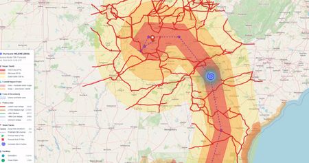
As organizations apply AI to real-world operations—from weather forecasting and infrastructure resilience to supply chains and environmental monitoring—geospatial data is becoming a critical enterprise input. GeoAI, or geospatial AI, applies deep learning, computer vision, and generative AI to geospatial data to help organizations understand and respond to physical-world change. Planetary Computer Pro gives organizations a foundation for production geospatial data and AI workflows at enterprise scale. But turning geospatial data into operational insight is still hard. Data is often large, fragmented, and spread across imagery, SAR, weather, video, LiDAR, and vector sources. Traditional GIS workflows also remain separate from modern data and AI platforms, making it difficult to bring geospatial intelligence into day-to-day enterprise operations. Today, we are announcing the general availability of Microsoft Planetary Computer Pro, Microsoft’s enterprise geospatial data platform for AI. Built natively on Azure and integrated with Microsoft Fabric and Microsoft Foundry, it helps organizations manage geospatial data as a reusable enterprise asset that can power analytics, applications, and operational workflows. What’s new in GA General availability brings reliability, interoperability, and developer capabilities organizations need to operationalize geospatial analytics and AI in production environments. Enterprise-grade reliability and governance Planetary Computer Pro adds enterprise-grade reliability and governance capabilities for production geospatial workloads. Standardized metadata, lineage tracking, and repeatable delivery workflows provide a governed foundation for geospatial data management at scale. Expanded support for modern geospatial formats Planetary Computer Pro now supports cloud-native raster formats such as Zarr, NetCDF, and GRIB2, as well as vector data formats (preview) including Shapefile, GeoJSON, and GeoParquet. A new Vector Tile API (preview) enables high-performance geospatial visualization and interactive applications. AI-native developer workflows New Model Context Protocol (MCP) server capabilities enable AI agents and copilots to interact with Planetary Computer Pro through natural-language workflows—helping developers streamline geospatial tasks and support geospatial AI application development. Deeper integration across the Microsoft data and AI ecosystem Planetary Computer Pro integrates more deeply with Microsoft Fabric and Microsoft Foundry, helping organizations bring geospatial intelligence into enterprise analytics and AI workflows. In Fabric Maps, customers can overlay and visualize geospatial layers from Planetary Computer Pro. Figure 1: Maps in Fabric connected to Microsoft Planetary Computer Pro Expanded commercial and premium data ecosystem Organizations can now acquire archive imagery and streamline access to commercial imagery through SkyWatch, and have it delivered into Planetary Computer Pro to simplify downstream analysis workflows. Geospatial data providers can also distribute datasets through the platform—for example, Microsoft AI weather datasets can now be accessed through Planetary Computer Pro for use in analytics and AI workflows. Together, these capabilities help organizations move from isolated geospatial projects to scalable, governed production systems—with tighter integration between geospatial data, enterprise analytics, and AI workflows. Built for enterprise geospatial analytics and AI Geospatial AI applies deep learning, computer vision, and generative AI to geospatial data to help organizations understand and respond to physical-world change. From weather forecasting and infrastructure resilience to environmental monitoring and supply chain intelligence, organizations are increasingly using geospatial AI to support operational decision-making. Many organizations already have access to powerful geospatial AI models. The harder task is operationalizing the data around them—ingesting datasets, preprocessing at scale, maintaining governance, and delivering outputs into downstream systems. Planetary Computer Pro provides a unified geospatial data foundation for end-to-end geospatial AI workflows. Organizations can manage geospatial data with consistent access, metadata, governance, and repeatable delivery pipelines across teams and systems. Integrated with Microsoft Fabric and Microsoft Foundry, Planetary Computer Pro helps organizations bring geospatial intelligence into analytics, applications, and AI workflows. AI outputs stored in Planetary Computer Pro can be analyzed in Fabric, surfaced in dashboards, or visualized in Fabric Maps to support operational decision-making. For example, you can use weather data managed in Planetary Computer Pro together with Aurora, Microsoft Research AI for Science’s foundation model of the Earth’s atmosphere, to generate hurricane forecasts, assess potential impacts on utility infrastructure, and support resiliency planning workflows. Customer and partner momentum Organizations across energy, climate resilience, agriculture, and supply chain optimization are using Planetary Computer Pro to bring geospatial intelligence into operations while reducing manual data engineering and supporting geospatial AI at enterprise scale. Space Intelligence is using Microsoft Foundry and Planetary Computer Pro to produce audit-grade land-cover and carbon maps from petabyte-scale satellite data. By moving beyond desktop-based geospatial workflows, the company has improved mapping speed and scalability, helping organizations access environmental intelligence across countries and regions. “With Microsoft Foundry and Planetary Computer Pro we’ve increased data production by 100 times, and our time for mapping has gone from six months to six weeks—a 75% reduction.” - Stephanie Earp, Head of AI, Space Intelligence Learn more: Space Intelligence fuels climate action with Microsoft Foundry, Planetary Computer | Microsoft Customer Stories BKW is using Planetary Computer Pro together with Microsoft AI weather datasets and the Aurora weather model to strengthen energy forecasting and infrastructure planning workflows. By integrating weather data into AI-driven operational systems, BKW can better assess infrastructure risk, improve resiliency planning, and support energy trading decisions. “This collaboration demonstrates how advanced AI capabilities and robust cloud infrastructure can be applied to one of the most strategic domains—energy, where weather plays a fundamental role. In a time of accelerated transformation, it supports our ambition to operate increasingly renewable-based systems, where generation is inherently weather-dependent, and to better anticipate and manage this variability with greater confidence and precision.” - Yamshid Farhat, Lead AI & Technology, BKW EY and Xoople are building a supply chain intelligence solution that brings satellite‑derived signals into demand forecasting, inventory optimization, and production planning. Using Planetary Computer Pro, Microsoft Fabric, and Microsoft Foundry, the solution connects earth observation data to enterprise supply chain workflows, helping organizations move from physical-world signals to operational decisions. “Supply chain planning has traditionally operated with limited visibility into real-world conditions. By combining EY’s supply chain expertise, Xoople’s geospatial intelligence, and Microsoft technologies including Planetary Computer Pro, Microsoft Fabric, and Microsoft Foundry, we are helping clients bring physical-world signals directly into enterprise planning workflows and make faster, more informed operational decisions.” - Dany Bou Laba Bassil, EY AI & Data Supply Chain Leader EY - UK has built an AI‑driven environmental platform powered by Planetary Computer Pro, Space Intelligence and EY accelerators to operationalize regenerative agriculture and identify supply chain risks such as deforestation and water scarcity—improving ROI, auditability, and climate‑risk mitigation. “We’re excited by the launch of Microsoft Planetary Computer Pro as it helps bring geospatial intelligence into the heart of enterprise decision-making. By combining Earth observation data, AI and business context on a trusted platform, organizations can move faster from fragmented environmental signals to actionable insight—whether that’s managing nature-related risk, improving resilience or supporting more sustainable operations” - Adam Hughes, EY Technology Leader, UK Government & Public Sector, and Microsoft Consulting Leader Ecosystem Momentum We are also expanding the Planetary Computer ecosystem with new partners and integrations. Customers can now discover and task the latest earth observation data through the SkyWatch Platform and deliver it into Planetary Computer Pro. This simplifies downstream analysis by reducing the need to ingest, index, and catalog individual data purchases. "Our enterprise customers tell us the hardest part of working with commercial imagery isn't the data, it's getting it into the systems where their analysts and models live. This integration [with Microsoft Planetary Computer Pro] closes that gap for organizations that are standardizing their geospatial data workflows on Microsoft technology." - David Proulx, Chief Product Officer, SkyWatch Microsoft Planetary Computer Pro now brings NVIDIA AI weather models into enterprise geospatial AI workflows through integration with Microsoft Foundry. Powered by NVIDIA Earth-2 technologies, these capabilities enable customers to combine governed geospatial and atmospheric data for forecasting, scenario planning, and operational risk analysis. “Making NVIDIA AI weather models available alongside Microsoft Planetary Computer Pro and Microsoft Foundry helps organizations operationalize advanced weather and geospatial intelligence in enterprise workflows. Built on NVIDIA Earth-2 technologies, these capabilities can accelerate forecasting, scenario analysis, and risk-aware decision-making.” - Mike Pritchard, Director of Climate Simulation Research at NVIDIA Get started with Planetary Computer Pro Planetary Computer Pro helps organizations turn geospatial data into analytics, AI, and operational workflows at enterprise scale. Deploy Planetary Computer Pro. Provision your geospatial data environment on Azure and start building governed, scalable data pipelines. Explore the Planetary Explorer Solution Accelerator. See how generative AI can simplify geospatial workflows with a solution built on Microsoft Foundry that enables natural-language exploration of Earth science data. Resources Learn more about Microsoft Planetary Computer Pro | Microsoft Azure Read the documentation at Microsoft Planetary Computer Pro | Microsoft Learn Explore MCP tools for developer workflows at Microsoft Planetary Computer Pro MCP Tools - Visual Studio Marketplace Learn how to integrate Microsoft Fabric Maps at Add a WMS or WMTS imagery layer to a map - Microsoft Fabric | Microsoft Learn Unified AI Weather Forecasting Pipeline through Aurora, Microsoft Foundry, and Microsoft Planetary Computer Pro | Microsoft Community Hub Foundry Labs @ Build 20262.5KViews3likes0CommentsIntroducing Microsoft Planetary Computer Pro Model Context Protocol Tools on VS Code
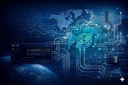
About Microsoft Planetary Computer Pro MCP Tools The Microsoft Planetary Computer Pro MCP Tools introduces a natural language-driven interface that simplifies how users interact with geospatial data managed with Microsoft Planetary Computer Pro. By integrating directly with GitHub Copilot in VS Code, our MCP exposes 35+ tools that connect directly to Microsoft Planetary Computer and Planetary Computer Pro, enabling users to perform data ingestion, STAC search, GeoCatalog management, visualization, and ingestion monitoring through natural language prompts. Instead of managing specialized APIs or stitching together multiple interfaces, MCP brings everything into a single, streamlined experience, reducing friction and accelerating time to insight. How Does it Work? MCP brings Microsoft Planetary Computer Pro workflows directly into the developer environment by embedding a natural language interface within VS Code through GitHub Copilot. As shown in Figure 2, users can describe tasks conversationally on VS Code, such as querying geospatial imagery, ingesting data, analyzing regions, or preparing datasets, and MCP translates those prompts into executable geospatial operations. This eliminates the need to write code or switch between tools, enabling faster iteration, tighter developer workflows, and a more intuitive path from idea to insight. To get started, install the extension from VS Code Marketplace. Instructions and a full list of tools are documented on the Install page. Key Features within the Toolset: STAC Search & Discovery With Microsoft Planetary Computer Pro MCP tools, users can simply describe what they’re looking for or search for data from an area of interest through an interactive map. Across both Planetary Computer public datasets and Microsoft Planetary Computer Pro GeoCatalog private datasets, MCP and STAC search enables fast, intuitive discovery of data across space, time, and metadata. GeoCatalog Management Beyond discovery, MCP streamlines the full lifecycle of geospatial data management. Users can create, configure, and manage STAC collections with ease, moving datasets from the Planetary Computer, defining rendering options like natural color or NDVI, and setting up mosaics or thumbnails, all through conversational prompts. This eliminates the traditional complexity of API calls and manual configuration, making it significantly easier to operationalize geospatial datasets and tailor them to specific mission or analysis needs. Data Ingestion Data ingestion, often one of the most complex and time-consuming steps, becomes seamless with MCP. Users can ingest data from Planetary Computer collections, or access ingestion APIs using simple prompts. From ingesting a single item to bulk onboarding entire datasets, MCP handles the orchestration, monitoring, and status tracking of ingestion workflows. This enables teams to quickly move from raw data to analysis-ready collections without needing to manage underlying pipelines. What Problem Does It Solve? Working with geospatial data today often requires navigating fragmented tools, managing specialized APIs across systems, and authentication. This complexity slows down geospatial workflows and increases the operational burden on customers. With MCP, users can: Eliminate the need for custom scripts and manual integrations Reduce time spent managing ingestion pipelines and catalog configurations Quickly move data between systems Focus on generating insights instead of managing infrastructure MCP orchestrates tasks behind the scenes, transforming complex geospatial workflows into a conversational experience that is intuitive and efficient. Why this Matters The release of the Microsoft Planetary Computer Pro Model Context Protocol marks a meaningful shift in how geospatial data and tasks are performed, accessed, managed, and operationalized. By unifying discovery, ingestion, catalog management, and troubleshooting into a single, natural language driven experience, MCP removes traditional complexity and empowers users to focus on what matters most, generating insight and driving outcomes. As geospatial workloads continue to grow in scale and importance, simplifying access to these capabilities becomes critical. MCP enables Microsoft Planetary Computer Pro users to move faster, lower barriers to entry, and unlock the full value of Microsoft Planetary Computer Pro without needing deep expertise in underlying systems or building special connectors to access various tools. As we continue to expand the Microsoft Planetary Computer Pro MCP toolset and integrate more automation of workflows and cross-pollinate between platforms, we envision a future where completing multi-step complex functions is as simple as having a conversation with GitHub CoPilot, accelerating innovation across GeoAI and enabling organizations to turn data into actionable intelligence at unprecedented speed. Get started today by installing the MCP Tools in VS Code and experience a new, seamless way to work with geospatial data on Microsoft Planetary Computer Pro. Resources Microsoft Planetary Computer Pro MCP Tools - Visual Studio Marketplace Microsoft Planetary Computer Pro | Microsoft Azure Microsoft Planetary Computer Pro | Microsoft Learn4.1KViews5likes0CommentsShaping the Next Era of Energy Decision Making with Geospatial Intelligence
Shaping the Next Era of Energy Decision Making with Geospatial Intelligence By Yves Pitsch, GM, Azure Space, Microsoft The global energy system is entering a new phase—one defined not just by a single transition to renewables, but by the convergence of forces that are reshaping how energy is produced, moved, secured, and governed. Artificial intelligence is accelerating electricity demand and increasing the complexity of the infrastructure needed to deliver it. Climate impacts are increasingly material, shaping infrastructure resilience, asset performance, and long‑term planning across the energy system. Geopolitics and supply chains are increasingly intertwined with technology decisions. As AI-driven workloads accelerate and energy systems face tighter constraints, the cost of disconnected decisions is rising fast. Across the energy and resources value chain, leaders are being asked to make decisions that are more interconnected, more time-sensitive, and more consequential than ever before. At Microsoft, we believe the next generation of energy decision-making will be powered by geospatial intelligence; the ability to understand how data, assets, risks, and opportunities interact across space and time. That belief is what’s driving our work on Microsoft Planetary Computer Pro. And it’s why we’re inviting customers and partners to help shape what comes next. From data-rich to decision-ready Energy and resources organizations do not lack data. In fact, many are overwhelmed by it. Satellite imagery, aerial and drone data, sensor networks, operational systems, market data, climate models, and regulatory inputs all play a role in how decisions get made. Yet too often, these data sources remain siloed—analyzed in isolation, interpreted by specialists, and disconnected from the AI systems that increasingly guide planning and operations. What’s missing is not more data, but context. Geospatial data provides that context. It connects information to real-world locations, physical assets, environmental conditions, and infrastructure constraints. It allows organizations to see not just what is happening, but where, why, and what happens next. However, operationalizing geospatial data at enterprise scale has historically been difficult—complex formats, fragmented tooling, and workflows that don’t integrate easily with mainstream data and AI platforms. Planetary Computer Pro is designed to change that. Introducing Planetary Computer Pro Planetary Computer Pro builds on the foundation of the Microsoft Planetary Computer , bringing geospatial intelligence into the heart of enterprise data and AI workflows. Unlike traditional GIS systems, Planetary Computer Pro is designed to operate inside modern data and AI stacks—treating spatial data as a native input to analytics, machine learning, and decision workflows. At its core, Planetary Computer Pro is a cloud-native platform that enables organizations to ingest, manage, and analyze their private geospatial data, securely, at scale, and in ways that integrate naturally with Azure, Microsoft Fabric , Microsoft Foundry, and partner solutions such as Esri. But more importantly, it’s built to make geospatial data usable. Not just for GIS experts, but for data scientists, engineers, and decision-makers across the organization. By treating geospatial data as a first-class input to AI and analytics, Planetary Computer Pro helps organizations move from static maps and point-in-time analysis to continuously updated spatial workflows, where geospatial data can be indexed, organized, discovered, queried, fused, and analyzed at scale for downstream applications. Why this matters for energy and resources leaders Energy systems are inherently spatial. Power grids, pipelines, renewable assets, supply chains, and communities all exist in physical space, and are increasingly influenced by environmental and geopolitical forces. Geospatial intelligence enables energy and resources leaders to: Plan infrastructure under uncertainty Model how climate variability, demand growth, and policy shifts interact across regions and time horizons. Assess physical climate risk Understand how flooding, heat, drought, or extreme weather impact specific assets, operations, and supply chains. Optimize operations across the value chain Combine location-based data with operational and market signals to improve reliability, efficiency, and resilience. Navigate permitting, compliance, and reporting Support sustainability and regulatory workflows with spatially precise, auditable insights. These aren’t isolated use cases—they are system challenges. And solving them requires platforms that can reason about interdependencies, not just optimize individual variables. Built with partners, shaped by customers One of the lessons we’ve learned from working in highly regulated, capital-intensive industries is that no single organization builds the future alone. Planetary Computer Pro is being developed in close collaboration with customers and partners across the energy and resources ecosystem; utilities, energy producers, technology providers, and solution builders who understand the realities of operating at scale. Our goal is not to prescribe a single solution, but to provide a flexible foundation that partners can extend and customers can adapt to their unique needs. This ecosystem approach is intentional. It ensures that Planetary Computer Pro reflects real-world requirements, from security and compliance to interoperability and performance, and that it evolves alongside the industry it serves. An invitation to shape what’s next That’s why we’re taking a collaborative approach to bringing Planetary Computer Pro to market. This is an invitation to engage early, to explore how spatial context can strengthen AI-driven decisions, and to co-create solutions that reflect the complexity of the world we operate in. If you’ll be at CERAWeek this week, we’d welcome the chance to connect—share what you’re building, see what we’re learning, and explore early collaborations around Planetary Computer Pro. The challenges ahead are real—but so is the opportunity to build intelligence that understands the systems we depend on. In the recent Microsoft Foundry blog on Aurora, we shared how foundation models can help organizations reason over complex, real-world signals; bringing that kind of capability together with spatial context is a powerful next step for the energy and resources industry. We look forward to shaping what comes next, together.