physical-world intelligence
2 TopicsAI-Enabled Map Production Using Microsoft's MARS Model
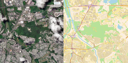
Maps have long served as the foundation for how organizations understand, navigate, and make decisions about the world. Yet generating and maintaining maps remains a highly manual, time-consuming, and costly process with susceptibility to human error. Traditional mapping workflows rely on skilled cartographers to manually analyze satellite imagery, identify geographic features with a human eye, and digitize them into map layers. The challenge of keeping maps up to date is well said by Michael Harres, SVP of Engineering Maps at TomTom. “Traditional maps, including early digital versions, were static snapshots, reliant on manual updates, outdated and unable to reflect real-time changes.” - Michael Harres, SVP of Engineering Maps at TomTom (Source: From Paper To AI: The Evolution Of Maps And What’s Next) While recent advances in generative AI have demonstrated impressive visual reasoning capabilities, most general-purpose models are not designed to generate the structured vector outputs (e.g. points, lines, and polygons) required by GIS workflows. They often produce rasterized sketches, illustrations, or incomplete representations that cannot be directly incorporated into enterprise mapping systems. ple Output from a General-Purpose AI Model Prompted to Generate a Map Today, we are excited to release the Map Autoregressive (MARS) model on Microsoft Foundry! MARS is a Geospatial AI model that automatically converts satellite imagery directly into structured, GIS-ready vector map data. Unlike traditional mapping approaches that rely on complex multi-stage pipelines, heuristic processes, and extensive post-processing, MARS’s key differentiator is its unified end-to-end architecture that automatically extracts geographic features and generates vector representations suitable for mapping and geospatial analysis. Unlike segmentation masks, vector outputs can be directly loaded into GIS systems, edited by analysts, and incorporated into downstream mapping, analytics, and operational workflows. Trained on large-scale geospatial datasets, MARS currently supports feature extraction for buildings, roads, railways, and waterbodies with a scalable ontology designed to expand over time. Microsoft recently published a research paper on MARS (http://aka.ms/marspaper), accepted by the International Conference on Learning Representations (ICLR) Conference, that provides a deep technical overview of the model’s architecture, training methodology, and performance. The MARS model from the paper uses the same architecture, adapted through a separate training process, and attains state-of-the-art performance on public benchmarks. Metrics for the Foundry model are available on its model card, which also demonstrates its ability to generate GIS-ready vector representations directly from satellite imagery. Figure 2: Microsoft MARS Model – This image shows a feature extraction output of MARS overlaid on input aerial imagery of London. The extracted features are rendered directly on top of the source image to illustrate how the model converts raw imagery into structured geospatial data. Buildings, roads, railways, and waterbodies represented as vector geometries, enabling organizations to generate and update maps at scale without labor-intensive manual digitization. Legend: Buildings → Orange polygons Roads → Yellow lines Railways → Red lines Waterbodies → Blue shaded polygons The Value of Automated Feature Extraction using MARS The volume of Earth observation data, and the pace at which infrastructure is changing around the world, is growing faster than organizations can manually track. As a result, there is an increasing need for automated solutions that can transform imagery into up-to-date maps at scale. With the MARS model, organizations can: Accelerate map production workflows with vectorized GIS outputs of map features Reduce manual human-labeling efforts Scale mapping operations across larger regions or under-represented areas Increase map update frequency Improve situational awareness Make faster, data-driven decisions MARS can be run with satellite images from geospatial data platforms, like Microsoft Planetary Computer Pro, providing an end-to-end workflow for automated map production. Users can ingest and manage aerial imagery within Microsoft Planetary Computer Pro, where data is stored and indexed using the STAC (Spatial Temporal Asset Catalog) standard for efficient discovery and search. MARS can perform feature extraction using input data from a user’s Microsoft Planetary Computer Pro GeoCatalog, with the resulting outputs stored back into Microsoft Planetary Computer Pro for downstream analysis. By seamlessly integrating data management and GeoAI inference into a single workflow, MARS and Microsoft Planetary Computer Pro help organizations transform raw satellite imagery into usable maps. Potential Applications Mapping underpins mission-critical workflows across government and commercial industries. When maps become incomplete, outdated, or inaccurate, the decisions and insights built on them can carry significant operational risk. As organizations increasingly invest in digital twins, geospatial analytics, and map-based decision making, there is growing demand for scalable AI-enabled solutions that can transform imagery into GIS map data. Here are several potential applications of MARS. Government and intelligence communities around the globe invest significant resources producing and maintaining maps because roads, buildings, and critical infrastructure are essential to mission planning, reconnaissance, operational logistics, disaster response, and situational awareness. Currently, producing maps often requires analysts to manually review imagery, digitize features, and reconcile information from multiple sources, which is a time-consuming and error prone process that struggles to keep pace with a rapidly changing world. Using MARS, analysts can automatically generate GIS-ready vector outputs from satellite imagery, dramatically reducing the effort required to update maps at a fraction of the cost compared to traditional workflows. Infrastructure operators, utilities, and transportation agencies currently rely on aerial surveys, field inspections, engineering reports, and manually maintained GIS datasets to track changes in the built environment. These approaches can be manual, costly, time-consuming, and difficult to perform frequently across large regions. To address these challenges, MARS provides automated feature extraction from satellite imagery, replacing labor-intensive mapping workflows with scalable, AI-driven map production. This enables organizations to maintain more current geospatial datasets for infrastructure planning, grid modernization, renewable energy expansion, and transportation network management. Telecommunication providers currently combine GIS analysis, third-party mapping datasets, demographic studies, and site surveys to determine where to expand network coverage networks across underserved and rapidly growing areas. However, these datasets can quickly become stale in rapidly growing areas, leading to missed opportunities, inaccurate coverage planning, and costly field validation efforts. MARS enables providers to continuously derive fresh GIS-ready vector data from satellite imagery, helping teams identify service coverage gaps, prioritize infrastructure investments, and accelerate broadband expansion into underserved regions. Mining and natural resource companies frequently use field surveys, drone operations, engineering assessments, and GIS teams to monitor roads, operational infrastructure, and site expansion across vast and remote regions to support mineral exploration, mine planning, and infrastructure management. Updating these datasets often requires significant manual effort and can lag behind changing on-the-ground conditions. MARS can continuously extract and update road networks, waterway features, and operational infrastructure across vast and often remote regions, enabling faster planning cycles and more informed operational decisions. Insurance providers currently rely on stale property records, government datasets, aerial surveys, and manual assessments to maintain property inventories and evaluate risk exposure. MARS can help maintain property inventories and accelerate risk assessment by automatically extracting building footprints and detecting changes from recent satellite imagery. Following natural disasters such as floods, hurricanes, or wildfires, insurers can generate up-to-date maps of buildings, roads, and communities to assess exposure, prioritize inspections, expedite claims triage, and improve portfolio management using current geospatial data rather than infrequent surveys and manually maintained datasets. As organizations increasingly invest in digital twins and smart city initiatives, MARS provides a scalable way to keep virtual representations synchronized with the physical world. Automatically extracting buildings, transportation networks, and other critical assets from new imagery helps ensure digital twins remain current and ready to support planning, simulation, and operational decision-making. Getting Started MARS is available today on Microsoft Foundry. To get started, 1. Deploy the MARS model from the Microsoft Foundry Model Catalog. a. You may need to request additional GPU compute quota in Microsoft Foundry (https://learn.microsoft.com/en-us/azure/foundry/how-to/quota). The MARS model requires the Standard_NC24ads_A100_v4 VM. 2. Set up your Azure Microsoft Planetary Computer Pro instance. 3. Within Microsoft Planetary Computer Pro GeoCatalog, ingest input satellite imagery data as a Spatial Temporal Asset Catalog (STAC) collection of Cloud Optimized GeoTIFFs (COGs). Commercial data is available from various providers and partners like SkyWatch. a. Input Imagery Recommended Specifications: i. Orthorectified satellite or airborne imagery with a ground sample distance (GSD) between 25cm – 75cm (the optimal GSD is 60cm) ii. Ingested into Planetary Computer Pro as an RGB COG and STAC metadata that specifies gsd, projection (e.g. proj:epsg), band information (e.g eo:bands), and accurate bounding box (bbox) and geometry fields b. Recommend Model Settings i. Optimal tiling: 512 x 512 pixels 4. Use the GeoAI SDK to run MARS against imagery from your Microsoft Planetary Computer Pro collection. 5. Generate production-ready vector layers for analysis, mapping, and downstream applications. References AI Model Catalog | Microsoft Foundry Models GeoAI SDK — GeoAI with Microsoft Planetary Computer Pro MARS - A Foundational Map Auto-Regressor | OpenReview Microsoft Planetary Computer Pro | Microsoft Azure Microsoft Planetary Computer Pro | Microsoft Learn4.1KViews3likes0CommentsIntroducing Physical-World Intelligence: How GeoAI Is Helping Expand Enterprise AI
Key Takeaways Physical-World Intelligence is the ability to combine data about the physical world, such as weather, satellite imagery, infrastructure, sensors, maps, environmental conditions, and asset locations, with enterprise data and AI to support operational and business decision-making. This article argues that enterprise AI is expanding beyond documents, transactions, and digital systems to include intelligence derived from real-world conditions. The central idea is simple: organizations can make better decisions when they can perceive current real-world conditions, anticipate how those conditions may change, and connect those insights directly to workflows and actions through transforming data into information into awareness into intelligence. Physical-World Intelligence helps organizations transform data into information, information into awareness, and awareness into intelligence, enabling real-world observations to be incorporated into enterprise workflows and decisions. Why Physical-World Intelligence Matters Imagine a utility operator preparing for an approaching severe storm. Weather AI models forecast storm conditions. Satellite imagery reveals infrastructure exposure. Enterprise systems provide context about critical assets, transmission corridors, and affected communities. Together, these inputs help answer operational questions: Which assets are at risk? Where should repair crews be positioned? Which customers may be impacted? How should operations adapt before the storm arrives? These decisions require more than data. They require the capability to transform observations into intelligence that supports action. We call this capability Physical-World Intelligence. Physical-World Intelligence is the ability to combine physical-world data, enterprise data, and AI to support operational decision-making. It extends enterprise intelligence beyond traditional digital systems to include weather, infrastructure, environmental conditions, assets, and other real-world factors that influence business outcomes. Recent advances in GeoAI are making it practical to integrate these signals into operational workflows. At Microsoft Build, Microsoft introduced the Geospatial and Earth Science domain on Microsoft Foundry, creating a dedicated destination for discovering and deploying AI models designed to analyze and generate insights to help businesses understand the physical world. The initial catalog includes seven models spanning weather forecasting, Earth observation analysis, image classification, object detection, full motion video and automated map generation. These include Microsoft's Aurora, MARS (Map Auto-Regressive System), EO Object Detection, Full motion video Object Detection and FTW-PRUE, alongside NVIDIA's Earth2Studio FCN3 and StormScope forecasting models. These models represent an important milestone for GeoAI. More importantly, they demonstrate a broader shift: AI systems are increasingly able to analyze not only digital information, but also the geospatial, environmental and other dynamic physical world data. From Enterprise Intelligence to Physical-World Intelligence For decades, documents, transactions, applications, and operational systems have successfully built the foundation for enterprise intelligence. However, it is becoming more obvious that many business outcomes are influenced by factors that exist outside those systems: A utility operator needs to understand how weather affects infrastructure reliability; An insurer needs to assess changing catastrophe exposure; A retailer needs to anticipate weather-driven demand; A manufacturer needs visibility into environmental and supply-chain disruptions; A government agency needs situational awareness during natural disasters. In each case, the most important signals often originate in the physical world. Advances in Earth observation, weather forecasting, cloud computing, and AI are making it possible to systematically transform those signals into intelligence and information that organizations can use. Together, these advances are helping create a new category of enterprise capability: Physical-World Intelligence. At its core, Physical-World Intelligence enables organizations to: Perceive the World Understand current conditions across assets, infrastructure, operations, and environments using satellite imagery, weather observations, drone data, sensors, and other geospatial information. Anticipate What Happens Next Predict how conditions may evolve and allow organizations to evaluate that potential impact on their operations, resilience, planning, and business outcomes. Coordinate Effective Action Integrate intelligence and insights into workflows and business processes to support their operational planning, coordination, and decision-making. These capabilities are becoming increasingly important across energy, utilities, insurance, government, agriculture, sustainability, manufacturing, and supply-chain operations. For example, utility storm operations use all three: understanding current infrastructure conditions, anticipating weather impacts, and coordinating response activities. GeoAI: The Technology Foundation for Physical-World Intelligence Physical-World Intelligence describes the business capability. GeoAI is one of the key technologies enabling it. GeoAI combines geospatial data, Earth observation, weather intelligence, machine learning, and foundation models to generate intelligence from real-world conditions. Today's GeoAI models demonstrate several important capabilities: Capability What It Enables Example Models Perception Understanding current conditions EO Object Detection, FTW-PRUE, MARS Anticipation Forecasting future conditions and risk Aurora, Earth2Studio FCN3, StormScope Decision & Action Supporting decisions and workflows Emerging geospatial reasoning models and AI agents Perception models help organizations extract meaningful information from imagery. For example, EO and FMV Object Detection identifies objects of interest, FTW-PRUE identifies agricultural field boundaries, and MARS automatically generates map features from aerial imagery. Anticipation models help organizations forecast weather, assess risk, and evaluate how conditions may evolve. Aurora, Earth2Studio, and StormScope are examples of this capability. As GeoAI continues to evolve, the focus is shifting from individual model predictions to end-to-end decision support. Organizations increasingly want AI systems that combine physical-world observations, enterprise context, and operational workflows to help them determine not only what is happening and what may happen next, but also what actions the organization should consider next. Why Models Alone Aren't Enough The rapid advancement of GeoAI models creates significant opportunities, but models alone do not create business outcomes. Forecasting a severe storm is only part of the challenge. Organizations must still determine what it means for their assets, operations, customers, and response plans. These decisions require combining model outputs with enterprise data and operational workflows. Many organizations still face four common challenges Data Gap Physical-world data is fragmented, heterogeneous, and constantly changing. Insight Gap Observations often remain isolated in dashboards and reports instead of becoming reusable intelligence. AI Gap Data must be standardized and connected with business context before AI systems can generate meaningful insights. Action Gap Insights must ultimately connect to enterprise workflows and decision-making systems. Physical-World Intelligence cannot be delivered through data alone, models alone, or applications alone. It requires a platform that connects all three. Microsoft Planetary Computer Pro: The GeoAI Data Plane This is where Microsoft Planetary Computer Pro fits into the architecture. Planetary Computer Pro serves as the GeoAI Data Plane, connecting physical-world data, GeoAI models, and enterprise workflows into a unified operational system. Just as enterprise data platforms make business data accessible to analytics and AI systems, Planetary Computer Pro makes physical-world data accessible to GeoAI models, applications, and enterprise workflows. Planetary Computer Pro helps organizations: Build a Unified Physical-World Data Foundation Ingest, catalog, govern, and manage satellite imagery, weather data, drone imagery, LiDAR, and enterprise geospatial information. Create AI-Ready Context Transform observations and model outputs into standardized, reusable intelligence that can be consumed by analytics applications and AI workflows. Connect Intelligence to Enterprise Systems Integrate intelligence with Microsoft Foundry, Microsoft Fabric, Power BI, Copilot experiences, and partner platforms such as Esri and QGIS. Returning to the storm operations example: Microsoft Foundry provides weather forecasting and GeoAI models. Planetary Computer Pro connects those models with inferencing input data and connects output predictions with geospatial data, infrastructure information, and operational context. Enterprise systems consume the resulting intelligence to support planning and response. Microsoft Foundry provides the model ecosystem. Planetary Computer Pro helps organizations integrate those models at enterprise scale. Accelerating Adoption with the GeoAI SDK To simplify the path from GeoAI experimentation to production, we provide the GeoAI SDK—a developer toolkit that connects geospatial data managed by Planetary Computer Pro with AI models hosted in Microsoft Foundry. Running geospatial AI models at enterprise scale requires more than deploying a model endpoint. Developers need to manage large imagery collections, identify relevant data, prepare inputs, execute inference workflows, and publish results in a format that can be consumed by downstream applications. The GeoAI SDK helps streamline this workflow. Using the GeoAI SDK, developers can: Discover and deploy supported GeoAI models from Microsoft Foundry. Define areas of interest and automatically discover relevant geospatial data. Prepare imagery and execute inference workflows at scale. Manage model outputs and publish results back into Planetary Computer Pro GeoCatalog. Integrate resulting intelligence into analytics platforms, applications, and enterprise workflows. The SDK currently supports models such as EOOS Object Detection and MARS Map Generation, enabling developers to detect objects, extract infrastructure, and generate map features from satellite imagery using a consistent workflow. The goal is simple: make it easier to move from experimenting with GeoAI models to building production-scale applications that deliver physical-world intelligence. Looking Ahead The introduction of the Geospatial & Earth Science domain in Microsoft Foundry represents an important milestone for GeoAI. But the larger opportunity extends beyond geospatial models. Organizations increasingly need AI systems that understand not only digital systems, but also the dynamic physical world around them. Whether preparing for severe storms, assessing wildfire risk, monitoring critical infrastructure, optimizing supply chains, or managing environmental impacts, organizations need intelligence that begins with understanding real-world conditions. Physical-World Intelligence represents the next evolution of enterprise AI. GeoAI provides the technology foundation. Microsoft Foundry provides the model ecosystem. Microsoft Planetary Computer Pro provides organizations with the GeoAI Data Plane that helps them to integrate those capabilities into their workflows. Together, they enable organizations to move from observations, to intelligence, to action. We are excited to see what developers, architects, data scientists, partners, and customers build next. The future of enterprise AI won't only help organizations understand documents and data. It will increasingly help organizations incorporate real-world conditions into planning and decision-making. Get Started Explore the Geospatial and Earth Science domain in Microsoft Foundry Learn more about Microsoft Planetary Computer Pro | Microsoft Azure & Microsoft Planetary Computer Pro | Microsoft Learn Build applications using the GeoAI SDK695Views0likes0Comments