- Subscribe to RSS Feed
- Mark Discussion as New
- Mark Discussion as Read
- Pin this Discussion for Current User
- Bookmark
- Subscribe
- Printer Friendly Page
- Mark as New
- Bookmark
- Subscribe
- Mute
- Subscribe to RSS Feed
- Permalink
- Report Inappropriate Content
Nov 14 2018 08:39 AM
I'm trying to create a map chart using counties in Missouri. The problem is that Dunklin County isn't populating with data, even though Dunklin County is included in the data range. Earlier, before I moved Stoddard County to the top of the data set, the Dunklin County data was showing in the Stoddard County geo area. Is there any way to fix this manually without Microsoft fixing its data?
- Mark as New
- Bookmark
- Subscribe
- Mute
- Subscribe to RSS Feed
- Permalink
- Report Inappropriate Content
Nov 17 2018 01:59 PM
Hi Jon,
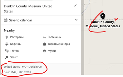
I don't think it's possible to fix this manually. Sometimes that works if some misinterpretation of names, you may play with them. Here is another situation. That is off-topic, just interesting. Maps uses Bing engine, and Bing maps show Dunklin exactly on the border with Stoddard
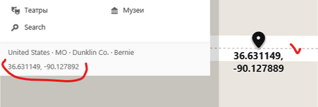
or, if enter state coordinates
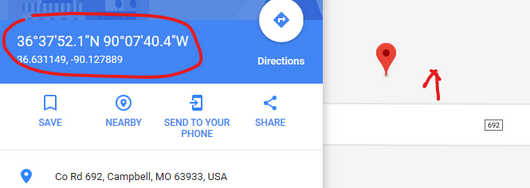
However, google for the same coordinates shows another side of 692 road which is in Stoddard.
I guess the reason of the error is something here, bug in bing geolocation. But that doesn't help in your concrete case...
- Mark as New
- Bookmark
- Subscribe
- Mute
- Subscribe to RSS Feed
- Permalink
- Report Inappropriate Content
Oct 17 2019 07:24 AM
This continues to be a problem almost a year latter. It makes the Filled Map chart option unusable for Missouri county maps which is a real drag for those of us in the Midwest.


